How can measurement data be transformed into high‑precision digital representations of infrastructure, and immediately generate structured, intelligent inventories from it? In the webinar, Johannes Braun from tmc demonstrates how combining high‑resolution point clouds (Digital Twins) with automated inventory management supports infrastructure managers, planners, and project managers in making safer, faster, and more cost‑efficient decisions.
The starting point: Fragmented and outdated infrastructure data
In practice, information about infrastructure and asset conditions is often scattered across old plans, different data sources, and manual surveys. The exact positions of signals, masts, overhead lines, or obstacles along the track are frequently unclear or not up‑to‑date.
This leads to:
- Planning errors due to outdated or incomplete information
- Repeated, costly on‑site inspections to clarify specific questions
- Lack of transparency in expansion, renovation, or renewal projects
- Higher costs and longer planning timelines
The challenge is not a lack of measurement data, but its preparation and usability.
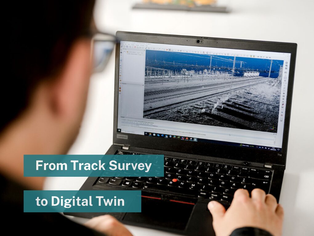
The solution: High‑precision point clouds as a Digital Twin
tmc has developed a process that translates measurement data into a high‑precision, spatially structured representation of the infrastructure: the Digital Environmental Twin Service (tmDETS).
The system works according to this principle:
- Automated track surveys using digital measurement systems (e.g. tmRTG for reference surveying) capture the precise track axis position
- Mobile Mapping: A measurement vehicle is equipped with laser scanners (LIDAR), RGB cameras, and inertial systems (e.g. Riegl VMX System)
- Data fusion: Captured laser and image data is linked with the absolute track geometry
- Colorized high‑precision point cloud: The result is a photorealistic, geometrically anchored point cloud depicting the infrastructure with 1 cm relative and 2 cm absolute accuracy.
With this point cloud, planners, engineers, and operators can work virtually on site – perform measurements from the office, inspect objects, and check clearances without ever needing to visit the site.
Inventory as a Service: Automated object detection and management
The webinar’s second focus is automated inventory management (tmARIS – Automated Railway Inventory Service).
Infrastructure objects are systematically detected, classified, and documented:
Detection methods:
- Video‑based capture: RGB camera data is analyzed with AI models (YOLO) – even from a distance, the system recognizes signals, masts, and other objects.
- Laser‑based capture: The 3D point cloud is also classified to precisely determine size, shape, and spatial position.
- Combined analysis: Overlaying image and point cloud data enables robust object detection under varying conditions
The system currently recognizes over 35 object classes – from signals and masts to rail barriers and foundation surfaces. Further categories for linear objects (e.g. noise barriers, cable trays) are in development.
Data refinement:
After automated detection, planners can manually refine – e.g. by setting reference points (lamp top, foundation surface) and adding specific attributes relevant to their field.
The end result is a structured geodatabase with full change logs, ready for integration into planning tools.
Real added value: From legacy plans to current reality
A key component of tmARIS is the comparison between existing planning documents and the newly captured reality.
Specifically:
- Old plans and drawings are compared with the digitized inventory
- Deviations are automatically detected and logged
- Updated plans and a detailed deviation report are delivered
This provides transparency on which assets are still correctly documented and which have changed – a foundation for reliable planning.
Productivity and cost efficiency
A core advantage lies in drastically reduced costs and times:
Efficiency gains over manual methods:
- No track possessions required: The measurement vehicle operates during regular service – no special runs or line blockages needed.
- No personnel protection costs: Without workers on track, costs for guarding and supervision are eliminated.
- Fast coverage: One team can survey over 50 km of double track per shift.
- Virtual re‑measurements: Questions or changes can be resolved 24/7 from the office – no additional trips required.
The digital surveying pays for itself through time savings, eliminated possessions, and virtual planning work already after a few projects.
Who benefits from this solution?
The webinar addresses a broad range of stakeholders:
- Infrastructure managers and maintainers: Need current, verifiable inventories as a basis for maintenance, planning, and regulation
- Infrastructure planners and surveyors: Benefit from high‑precision point clouds and structured data – central for Building Information Modeling (BIM) and expansion projects
- Signaling planners: Use inventory data and geometries for signaling system and railway telecommunications planning
- Project and site managers: Receive digital as‑built and as‑is conditions, change logs, and schedules from the data
- Machine manufacturers and operators: Can identify deployment conditions and clearance conflicts in advance
Practical implementation: From project to standard operations
The webinar also covers concrete implementation steps:
First step:
Contact tmc to jointly clarify requirements – which track sections, object classes, and accuracy levels are needed?
Proven model:
Many projects start with a Proof of Concept on a manageable section to validate benefits and quality before scaling to larger networks.
Data ownership:
Important point: All data belongs to the infrastructure manager. tmc provides capture and processing as a service.
Digital Twin as the core of the future
The combination of high‑precision point clouds, automated object detection, and structured inventory management defines a new way to document, plan, and operate railway infrastructure. Instead of clarifying individual questions on site, a trusted digital replica of the track is available – always accessible, searchable, and comparable.
With tmDETS and tmARIS, this future is reality today – creating the foundation for safer, faster, and more economical decisions in track maintenance and planning.